About JPSS
The Joint Polar Satellite System (JPSS) is a series of high tech satellites that keep an eye on the weather and environment. These satellites circle the Earth from North Pole to South Pole 14 times each day as the planet spins below. This allows JPSS to see the whole Earth twice every day.
NOAA-20 —the first satellite in the JPSS series, previously called JPSS-1 — launched on November 10, 2017. It has a suite of advanced instruments to collect information about what’s happening in the atmosphere, on the land, and on the surface of the oceans. From its orbit 512 miles above Earth, NOAA-20 helps us:
- Create more accurate weather forecasts up to 7 days in advance.
- Track how the weather affects plants, including forests and the crops that grow our food.
- Monitor ocean health by taking detailed measurements of water temperature and color.
- Keep tabs on the atmosphere to create earlier warnings of severe weather.
- Watch for volcanoes and forest fires around the world to monitor air quality and enhance public safety.
Partners
The Joint Polar Satellite System (JPSS) program works closely with national and international partners from government, universities and private industry to help build our satellites and the infrastructure that support them, as well as to help them utilize our satellite data to support weather operations and long-term research.
AL
Cooperative Institute for Satellite Earth System Studies (CISESS)
University of Alabama – Tuscaloosa, AL
Northern Gulf Institute (NGI)
Dauphin Island Sea Lab – Dauphin Island, AL
CA
Center for Earth System Sciences and Remote Sensing Technologies (CESSRST)
San Diego State University – San Diego, CA
Cooperative Institute for Marine Ecosystems and Climate
San Diego, CA
CO
Cooperative Institute for Research in Environmental Sciences (CIRES)
Boulder, CO
Cooperative Institute for Research in the Atmosphere (CIRA)
Fort Collins, CO
FL
Cooperative Institute for Satellite Earth System Studies (CISESS)
Florida International University – Miami, FL
Northern Gulf Institute (NGI)
Florida State University – Tallahassee, FL
GA
Cooperative Institute for Satellite Earth System Studies (CISESS)
University of Georgia – Athens, GA
LA
Northern Gulf Institute (NGI)
Louisiana State University – Baton Rouge, LA
MD
Center for Earth System Sciences and Remote Sensing Technologies (CESSRST)
University of Maryland, Baltimore County (UMBC) – Baltimore, MD
Cooperative Institute for Satellite Earth System Studies (CISESS)
University of Maryland (UMD) – College Park, MD
MI
Cooperative Institute for Satellite Earth System Studies (CISESS)
University of Michigan – Ann Arbor, MI
MS
Northern Gulf Institute (NGI)
Mississippi State University – Starkville, MS
NC
Cooperative Institute for Satellite Earth System Studies (CISESS)
North Carolina State University (NCSU) – Raleigh, NC
NE
Cooperative Institute for Satellite Earth System Studies (CISESS)
University of Nebraska Medical Center – Omaha, NE
NY
Center for Earth System Sciences and Remote Sensing Technologies (CESSRST)
The City University of New York (CUNY) – New York, NY
Cooperative Institute for Satellite Earth System Studies (CISESS)
The City University of New York (CUNY) – New York, NY
OR
Cooperative Institute for Satellite Earth System Studies (CISESS)
Oregon State University – Corvallis, OR
PR
Center for Earth System Sciences and Remote Sensing Technologies (CESSRST)
University of Puerto Rico, Mayaguez (UPRM) – Mayaguez, PR
SC
Cooperative Institute for Satellite Earth System Studies (CISESS)
University of South Carolina – Columbia, SC
SD
Cooperative Institute for Satellite Earth System Studies (CISESS)
South Dakota State University – Brookings, SD
TX
Center for Earth System Sciences and Remote Sensing Technologies (CESSRST)
University of Texas, El Paso (UTEP) – El Paso, TX
VA
Center for Earth System Sciences and Remote Sensing Technologies (CESSRST)
Hampton University – Hampton, VA
Cooperative Institute for Satellite Earth System Studies (CISESS)
George Mason University – Fairfax, VA
WA
Cooperative Institute for Satellite Earth System Studies (CISESS)
Pacific Northwest National Laboratory – Richland, WA
Wash DC
Cooperative Institute for Satellite Earth System Studies (CISESS)
Howard University – Washington, DC
WI
Cooperative Institute for Meteorological Satellite Studies (CIMSS)
Madison, WI
AK
Geographic Information Network of Alaska (GINA)
Fairbanks, AK
HI
University of Hawaii
Honolulu, HI
MA
Massachusetts Institute of Technology Lincoln Laboratory
Lexington, MA
Woods Hole Oceanographic Institution
Woods Hole, MA
MI
Michigan Technological University
Houghton, MI
RI
University of Rhode Island
Kingston, RI
UT
Utah State University’s Space Dynamics Laboratory
North Logan, UT
VA
George Mason University
Fairfax, VA
AK
ASRC Federal System Solutions
Barrow, AK
AL
General Dynamics Mission Systems
Cullman, AL
AR
BEI Precision
Maumelle, AR
Ducommun Labarge Technologies, Inc.
Berryville, AR
AZ
Northrop Grumman Space Systems
Gilbert, AZ
Honeywell Aerospace
Glendale, AZ
MOOG
Gilbert, AZ
CA
Flight Microwave
El Segundo, CA
Northrop Grumman Space Systems
Azusa, CA
Raytheon Intelligence & Space
El Segundo, CA
Northrop Grumman Space Systems
San Diego, CA
United Launch Alliance (ULA)
Vandenberg Air Force Base (VAFB), CA
Microchip Microsemi
Garden Grove, CA
Moog, Inc.
Chatsworth, CA
Spectrum Scientific, Inc.
Irvine, CA
Electronic Source Company
Van Nuys, CA
Cicon Engineering
Van Nuys, CA
L3Harris Datron Advanced Technologies
Simi Valley, CA
L3Harris Electron Devices
Torrance, CA
Alliance Space Systems LLC
Los Alamitos, CA
Zax Millimeter Wave Corp.
Upland, CA
Viavi Solutions Inc.
Santa Rosa, CA
Applied Aerospace Structures Corp.
Stockton, CA
Cardic Machine Products Inc.
Carson, CA
Superior Jig, Inc.
Anaheim, CA
Avnet Inc.
Woodland Hills, CA
KCA Electronics Inc.
Anaheim, CA
The Aerospace Corporation
El Segundo, CA
Lucix Corporations
Camarillo, CA
Teledyne Microsystems
Mountain View, CA
Dow-Key Microwave
Ventura, CA
Leonardo DRS Electro-Optical & Infrared Systems
Cypress, CA
VACCO
South El Monte, CA
Vanguard Composites
San Diego, CA
CO
Ball Aerospace
Boulder, CO
AMERGINT Technologies
Colorado Springs, CO
Sierra Nevada Corporation
Louisville, CO
Cobham Inc.
Colorado Springs, CO
Custom Microwave
Longmont, CO
Raytheon Intelligence & Space
Aurora, CO
FL
Tower Optical
Boyton Beach, FL
Sypris Electronics
Tampa, FL
GA
EMS/Honeywell
Norcross, GA
IN
L3Harris Technologies
Fort Wayne, IN
MA
Opticraft
Woburn, MA
Materion Precision Coatings
Westford, MA
Litron, Inc.
Agawam, MA
Analog Devices
Chelmsford, MA
API Technologies
Marlborough, MA
Adcole
Marlborough, MA
Millitech Corp.
Northampton, MA
MD
The Aerospace Corporation
Lanham, MD
Lockheed Martin
Bethesda, MD
Raytheon Intelligence & Space
Lanham, MD
StormCenter Communications
Lanham, MD
SAIC
Lanham, MD
Qwaltec
Lanham, MD
ASRC Federal
Lanham, MD
The Hammers Company
Lanham, MD
Millennium Engineering and Integration Company
Lanham, MD
GVT LLC
Lanham, MD
Conceptual Analytics
Glenn Dale, MD
Stinger Ghaffarian Technologies
Lanham, MD
Sage Services Group
Lanham, MD
Business Integra
Lanham, MD
X3M Systems
Lanham, MD
Stellar Solutions
Lanham, MD
General Dynamics
Lanham, MD
Embedded Flight Systems, Inc.
Lanham, MD
Lentech, Inc
Lanham, MD
AeroTek
Lanham, MD
Jeffries Technology Solutions
Lanham, MD
Science and Technology Corporation
Lanham, MD
Global Science and Technology Inc
Lanham, MD
Telophase Corporation
Lanham, MD
L3Harris
Lanham, MD
KBRWyle
Lanham, MD
Vantage Systems, Inc
Lanham, MD
ATA Aerospace
Lanham, MD
GAMA-1 Technologies
Lanham, MD
ActioNet
Lanham, MD
ITT Systems Corporation
Lanham MD
MN
General Dynamics
Minneapolis, MN
Aerospace Fabrication & Materials, LLC
Farmington, MN
Honeywell International Corp.
Plymouth, MN
MO
EaglePicher Technologies
Joplin, MO
NH
Amphenol Backplane System
Nashua, NH
Labsphere Inc.
North Sutton, NH
Timken
Keene, NH
NJ
SRI International
Princeton, NJ
Cobham - ACC
Eatontown, NJ
NY
Cobham
Hauppage, NY
Miteq
Hauppage, NY
Taber Industries
North Tonawanda, NY
OH
Norman Noble, Inc.
Highland Heights, OH
L3Harris
Mason, OH
PA
Sechan Electronics Inc.
Lititz, PA
TN
AdTech Ceramics Company
Chattanooga, TN
TX
EO Innovations
Richardson, TX
Arrow Electronics Inc.
Plano, TX
Wenzel and Associates
Austin, TX
Southwest Research Institute
San Antonio, TX
UT
Northrop Grumman Space Systems
Magna, UT
VA
Millenium Engineering and Integration Company
Arlington, VA
SAIC
Reston, VA
AT&T
Oakton, VA
BAE Systems Information
Manassas, VA
WA
Aerojet
Redmond, WA
WV
Global Science and Technology Inc
Fairmont, WV
AK
U.S. National Weather Service (NWS) Alaska Region HQ
Anchorage, AK
NOAA Fairbanks Command and Data Acquisition Station (FCDAS)
Fairbanks, AK
Bureau of Land Management, Alaska Fire Service (AFS)
Fort Wainwright, AK
AL
Short-term Prediction Research and Transition Center (SPoRT)
NASA’s Marshall Space Flight Center – Huntsville, AL
CA
Naval Research Lab Marine Meteorology Division (NRL-MMD)
Monterey, CA
Fleet Numerical Meteorology and Oceanography Center (FNMOC)
Monterey, CA
National Marine Fisheries Service (NMFS)
Sacramento, CA
National Weather Service (NWS) River Forecast Center (RFC)
Sacramento, CA
NASA Jet Propulsion Laboratory
Pasadena, CA
CO
NOAA Earth System Research Laboratory (ESRL)
Boulder, CO
University Corporation for Atmospheric Research (UCAR)
Boulder, CO
FL
NASA’s Kennedy Space Center
Merritt Island, FL
National Hurricane Center
Miami, FL
GUAM
National Weather Service (NWS) Weather Forecast Office
Tiyan, Guam
HI
Naval Maritime Forecast Center/Joint Typhoon Warning Center
Pearl Harbor, HI
ID
NOAA Air Resources Laboratory
Idaho Falls, ID
MA
National Weather Service (NWS) Northeast River Forecast Center
Norton, MA
MD
NOAA Satellite Operations Facility (NSOF)
Suitland, MD
Direct Readout Laboratory (DRL)
Greenbelt, MD
NASA’s Goddard Space Flight Center
Greenbelt, MD
National Centers for Coastal Ocean Science (NCCOS)
Silver Spring, MD
National Centers for Environmental Prediction (NCEP)
College Park, MD
Air Resources Laboratory (ARL)
College Park, MD
National Marine Fisheries Service (NMFS)
Silver Spring, MD
NOAA Air Resources Laboratory
College Park, MD
National Environmental Satellite Data and Information Service (NESDIS)
Silver Spring, MD
MN
National Weather Service North Central River Forecast Center
Chanhassen, MN
National Weather Service North Central River Forecast Center
Chanhassen, MN
MO
National Weather Service Missouri Basin River Forecast Center
Pleasant Hill, MO
MS
Naval Oceanographic Office (NAVOCEANO)
Stennis Space Center, MS
NE
Air Force Weather Agency (AFWA)
Offutt Air Force Base, NE
NM
NASA’s White Sands Complex
Las Cruces, NM
NV
NOAA Air Resources Laboratory-added to Partner Modal 06/15
Las Vegas, NV
OK
NOAA Hazardous Weather Testbed
Norman, OK
PR
National Weather Service (NWS) Weather Forecast Office
San Juan, PR
RI
NOAA Northeast Fisheries Science Center
Narragansett, RI
TN
Government NOAA Air Resources Laboratory
Oak Ridge, TN
TX
National Weather Service West Gulf River Forecast Center
Fort Worth, TX
UT
United States Department of Agriculture (USDA) Forest Service Remote Sensing Application Center
Salt Lake City, UT
VA
NASA Langley Research Center (LaRC)
Hampton, VA
National Science Foundation (NSF)
Alexandria, VA
Wash DC
Naval Research Laboratory
Washington, DC
WV
NOAA Consolidated Backup (CBU) Facility
Fairmont, WV
NASA’s Katherine Johnson Independent Verification and Validation Facility
Fairmont, WV
Initiatives
The Joint Polar Satellite System (JPSS) Proving Ground Initiatives are efforts to improve NOAA services through optimizing the use of satellite data along with other sources of data and information. The initiatives comprise a team of developers and users working together to improve an application in a testbed environment, providing assessments of utility from the users and feedback to the developers.
- Arctic
- Aviation Weather
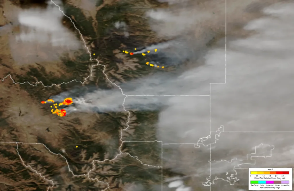
- Fire and Smoke
- Hurricanes and Tropical Storms
- Hydrology
- Ocean and Coastal
- Volcanic Hazards
- River Ice and Flooding
- Sound Applications
- Training
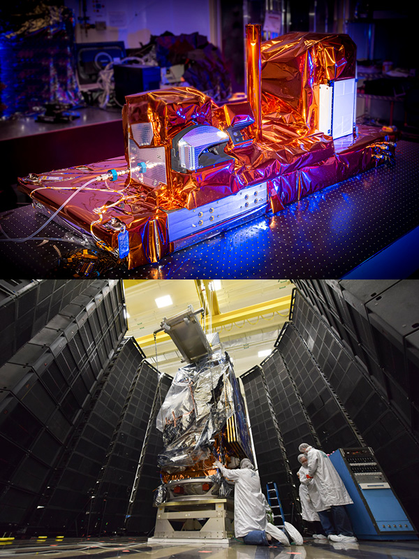
Spacecraft
The Joint Polar Satellite System (JPSS) spacecraft provides multiple functions such as communication, command, data handling, attitude control, propulsion and serves as a platform for the weather instruments.
Spacecraft
The Joint Polar Satellite System (JPSS) spacecraft provides multiple functions such as communication, command, data handling, attitude control, propulsion and serves as a platform for the weather instruments.
Instruments
The Advanced Technology Microwave Sounder (ATMS) instrument is the next generation cross-track microwave sounder providing atmospheric temperature and moisture for operational weather and climate applications.
The Clouds and the Earth’s Radiant Energy System instrument measures reflected sunlight and thermal radiation emitted by the Earth.
The Cross-track Infrared Sounder (CrIS) instrument is the first in a series of advanced operational sounders that provides more accurate, detailed atmospheric temperature and moisture observations for weather and climate applications.
The Visible Infrared Imaging Radiometer Suite (VIIRS) instrument collects visible and infrared imagery and global observations of land, atmosphere, cryosphere and oceans.
The Libera instrument will replace CERES on the JPSS-3 spacecraft. Libera will measure solar radiation to maintain the 40-year data record of the balance between the solar radiation entering Earth’s atmosphere and the amount absorbed, reflected, and emitted. This is a key factor in determining Earth’s climate.
The Ozone Mapping and Profiler Suite (OMPS) tracks the health of the ozone layer and measures the concentration of ozone in the Earth’s atmosphere.
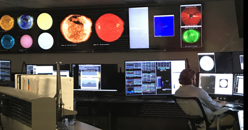
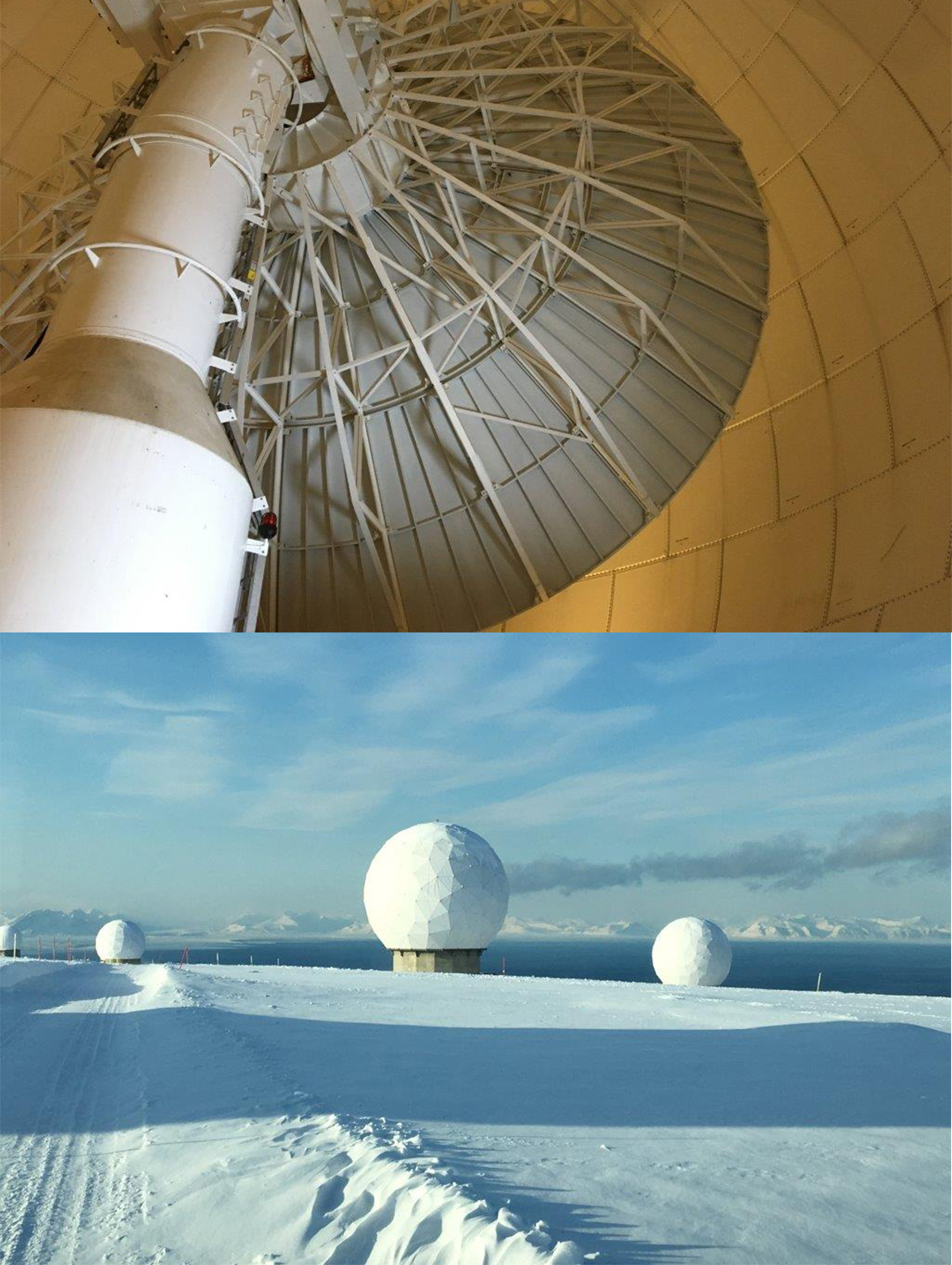
Ground System
The Joint Polar Satellite System (JPSS) Ground System supports NOAA-20 and a diverse set of low-Earth-orbiting satellites used for operational weather forecasting, environmental monitoring and climate research.