
Orbiting Insights: Transforming Sargassum Seaweed Detection and Monitoring From Space

January 10, 2024

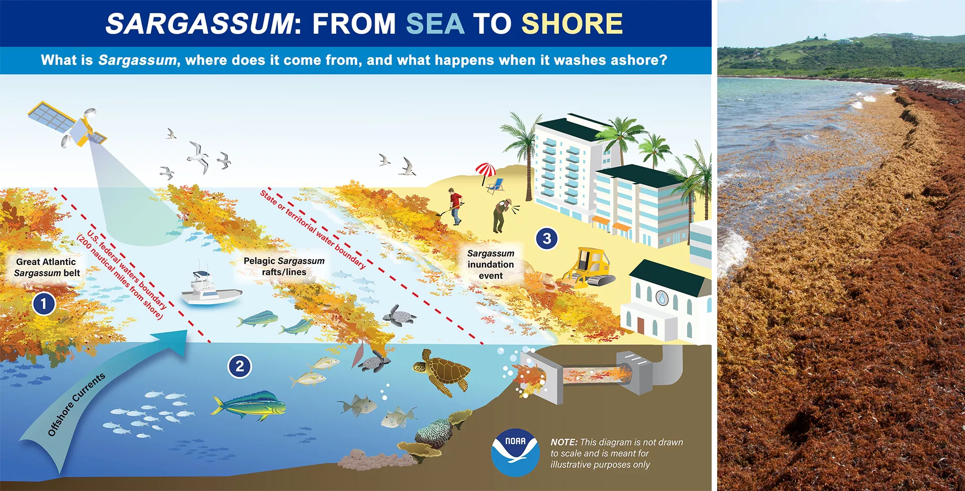
In the vastness of the open ocean, Sargassum seaweed, a floating brown macroalgae, forms large mats that serve as crucial habitats for various marine species. While providing refuge and nourishment in the sea, Sargassum becomes problematic when it reaches coastal areas in excessive amounts, leading to significant environmental, economic, and public health issues.

When Sargassum builds up along coastlines, its decomposition depletes oxygen levels, leading to dead zones that threaten marine life, including key fish species crucial for the economy. This accumulation also hinders sunlight penetration, adversely affecting vital underwater habitats such as coral reefs and seagrass beds. Tourism also suffers greatly from Sargassum inundation events, with the unsightly accumulation and foul smell of decaying seaweed on beaches driving away visitors, leading to considerable economic impacts on coastal communities. Moreover, rotting Sargassum emits hydrogen sulfide gas, posing serious health risks like respiratory problems and other ailments.


This infographic illustrates the movement of Sargassum from sea to shore. Out at sea, Sargassum provides important fish and wildlife habitat. However, this free-floating algae often washes ashore in great quantities due to strong wind and water currents. Masses of this algae beaching on shore can harm coastal ecosystems, drive away tourists, and pose public health threats. NOAA is working to help coastal communities address the growing problem of what experts call "Sargassum inundation events." This infog
Left: This infographic illustrates the movement of Sargassum from sea to shore. Out at sea, Sargassum provides important fish and wildlife habitat. However, masses of Sargassum often wash ashore in great quantities due to strong wind and water currents, wreaking havoc on coastal communities and ecosystems. These instances are called “Sargassum inundation events.” Source: NOAA NOS. Right: A beach on Saint Martin in the Caribbean covered in Sargassum seaweed on November 19, 2011. Photo by Flickr user Mark Yokoyama. Used under a Creative Commons license. Source: NOAA AOML.

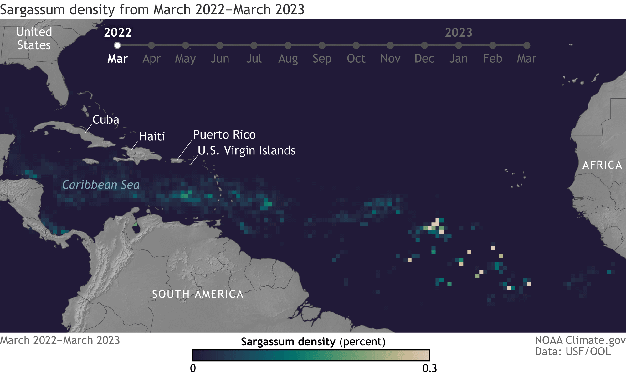
The Great Atlantic Sargassum Belt (GASB), a massive Sargassum bloom stretching from West Africa to the Gulf of Mexico, has been causing problems along the coastlines of the tropical Atlantic, Caribbean, and Gulf of Mexico nearly every year since 2011. Predicting the movement and impact of the GASB is complex due to the dynamic nature of oceanic and atmospheric factors that influence Sargassum distribution. The animation below shows the density and movement of Sargassum in the GASB as it moves across the Atlantic between March 2022 and March 2023, where lighter colors denote higher density.

This data visualization animation shows the change in the density of Sargassum from March 2022 to March 2023. The animation highlights the regions of the Caribbean Sea, the eastern coast of Central America, and the northern coast of South America. There are markers for locations such as the United States, Cuba, Haiti, Puerto Rico, and the U.S. Virgin Islands. The months of the year 2022 through early 2023 are indicated across the top. The density of Sargassum is indicated by color-coded squares, with a scal
Monthly maps of Sargassum density in the Atlantic, Caribbean, and Gulf of Mexico from March 2022 to March 2023. At the start of the animation, small patches of Sargassum are scattered across the Caribbean Sea and tropical Atlantic. As the season moves toward summer, the density increases, and the Sargassum shifts northward, allowing more seaweed to spread into the Caribbean and Gulf of Mexico. The amount of Sargassum declines over fall and winter. Animation by NOAA Climate.gov, based on data provided by the University of South Florida Optical Oceanography Laboratory.

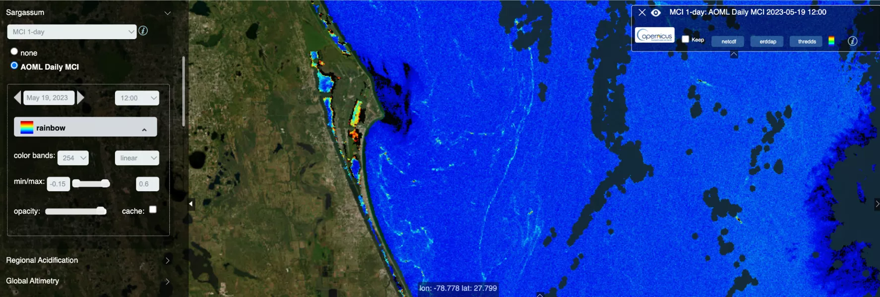
To manage these challenges, researchers have turned to low Earth orbit (LEO) observations. LEO satellites offer extensive and repeated coverage, crucial for monitoring the vast expanses of the GASB. Instruments such as the JPSS Visible Infrared Imaging Radiometer Suite (VIIRS) provide daily global coverage useful for tracking large Sargassum mats in the open ocean, while Copernicus Sentinel-2 satellites offer detailed imagery for smaller blooms closer to shore. Data like these are vital for predicting Sargassum inundation events and aiding in effective proactive action and response strategies.

The image is a triptych of satellite images showing the same geographical area captured by different satellite sensors: VIIRS_N20, MODIS_TERRA, and a combined OLCI_S3+VIIRS_N20+MODIS_TERRA. These images are color-coded to highlight features such as the concentration of sargassum, a type of seaweed, in the ocean. Shades of light blue represent high concentrations of sargassum, which are especially prevalent in the combined OLCI_S3+VIIRS_N20+MODIS_TERRA image. Each panel is labeled with the name of the satell
These images from August 2, 2022, illustrate how combining data from various satellite sensors enhances Sargassum detection by filling gaps and improving spatial resolution. The data are sourced from different instruments: NOAA-20 VIIRS (left), NASA Terra MODIS (center), and a composite from Sentinel-3 OLCI, NOAA-20 VIIRS, and Terra MODIS (right). In these images, light turquoise represents Sargassum, medium blue shows clouds, and dark blue indicates water.

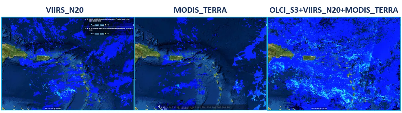
Scientists at NOAA CoastWatch, NOAA Atlantic Oceanographic and Meteorological Laboratory (AOML), the National Autonomous University of Mexico (UNAM), among others, are developing Sargassum detection and prediction models that combine data from various satellite sensors. These models, integrating advanced techniques like machine learning, are essential for creating effective Sargassum monitoring systems. This research is crucial for understanding Sargassum dynamics and supporting decision-making processes in affected coastal communities.

Screenshot of Ocean Viewer showing the presence of Sargassum along Central Florida on May 19, 2023. On the left side, there is a control panel with various adjustable settings, such as date and time (May 19, 2023, at 12:00), color representation (rainbow), and color bands. The visualization itself shows a coastal region with land on the left and sea on the right. The colors represent the Maximum Chlorophyll Index (MCI) that identifies those areas with high concentrations of chlorophyll. We can see the chara
Screenshot of the NOAA Ocean Viewer tool showing the presence of Sargassum along Central Florida on May 19, 2023. The Maximum Chlorophyll Index (MCI) identifies areas with high concentrations of chlorophyll. Characteristic lines of high MCI are seen along the coast, indicating the presence of Sargassum. There are also high values of MCI in the lagoons near Cape Canaveral that do not represent Sargassum, but rather, coastal eutrophic areas. Source: NOAA Ocean Viewer.
Magazine cover image with image of a rocket launching at night

To dive deeper into how these innovations are shaping our response to the Sargassum challenge, the upcoming 2023 JPSS Annual Science Digest, published later this month, offers an in-depth analysis. For more information, visit www.nesdis.noaa.gov/jpss-digest.